In Whitworth, local government services are provided by three local authorities - Whitworth Town Council, Rossendale Borough Council and Lancashire County Council. Whitworth Town Council consists of 12 elected members (Councillors), who are served by a Town Clerk. The Mission Statement of Whitworth Town Council is 'To improve the quality of life for the community of Whitworth'. The Town Council offices and Council Chamber are located in the Civic Hall complex in Whitworth.
In 2006, Whitworth Town Council became the 347th Town or Parish Council in the UK to achieve Quality Status and was re-accredited in 2011.
The status gives confidence to partner Councils and other organisations that the Town Council can deliver excellent services and value for money to the town's residents.
Whitworth Parish Council
- Employs a part-time Parish Lengthsman and full time Town Caretaker who, between them, keep the town as clean and tidy as possible
- Acts as a pressure group upholding the rights and values of the Township
- Acts as a sounding board for local opinion
- Acts as a centre for retaining and enforcing the Town's historical, cultural and social identity
- Inspects and comments on all planning applications and is consulted on new bye laws
- Actively encourages voluntary initiatives and works hard to encourage tourism and economic regeneration
- Nominates school governors and appoints trustees to local charities and representatives on such bodies as the Whitworth Sports Council, Police meetings and the Healey Dell Joint Management Committee
- Produces the Whitworth Valley News magazine
- Facilitates this website
Whitworth Town Council obtains the money it needs to carry out the services it provides by levying a precept on the Council Tax collected by Rossendale Borough Council (as detailed on your Council Tax bill). The Town Council's Annual Report is available to download and view on this website.
Town Council Staff
Whitworth Town Council's officer (Town Clerk) is Rachel Hodson. Rachel has been in post since 2022 and is your first point of call for anything related to Whitworth Town Council. Born and brought up in Rossendale, Rachel has lived in Whitworth with her young family since 2016. Her background is in accounts preparation and worked as a registered nurse for 13 years.
Whitworth's Town Caretaker is Glen Iliff. Glen lives in Whitworth and works as Caretaker full-time; he has been in post since 2007. His main duties are to remove litter from all public areas around the village, and to report any problems back to the Clerk.
Whitworth's Parish Lengthsman is Chris Rothwell. Chris has been Lengthsman since Jan 2024. He works 7.5 hours a week for the Council, and his role is to carry out basic maintenance around the town.
History of the Town Council
Whitworth Town Council was formed in 1974 following the reorganisation of local government in England. Prior to this date, Whitworth Urban District Council was the administrative body in the Valley, but was abolished following the reorganisation.
The history of local government in Whitworth began 100 years before this, in 1874. The latter end of this particular century saw a great deal of local development. As a result, a Local Board was set up in 1874 to administer Whitworth. Further independence arrived towards the end of the century with the creation of the Parish of Whitworth, one of 19 new parishes carved out of the original vast Rochdale Parish. Complete independence came in June 1894, when an urban district council replaced the Local Board. The first meeting was held on 3 January 1895 and the first chairman (appropriately enough) was a Mr William Ernest Whitworth. Whitworth had thus, at last, become ecclesiastically and administratively free of its neighbour. The wheel turned full circle in 1974 when the Urban District Council was abolished, and Whitworth was absorbed into the newly created Rossendale Borough Council.
The Urban District Council did much to shake off the legacy of the 19th century, and Whitworth became as progressive a place, for its size, as any in Lancashire. For example, in four days, 325 officials travelled to Whitworth, then one of Lancashire's smallest local authorities, to inspect the unique housing development at Leavengreave.
Whitworth - Town & Region
Whitworth is a thriving town, population approximately 7,800, which is situated in the Rossendale Valley in Lancashire, in the North West of England. Whitworth is nestled in the foothills of the Pennines, between the towns of Bacup to the north and Rochdale to the south.
Whitworth sits right on the tip of the Lancashire boundary, bordering Greater Manchester to the south (Rochdale), with West Yorkshire just over the easterly hills in Todmorden.
The township of Whitworth embraces the entire length of the Whitworth Valley, covering an area of around seven square miles. It is a long, thin village, consisting of the communities of Healey, Whitworth, Facit and Shawforth, all of which are linked by the A671, part of the great turnpike road built in the 18th century to link Manchester to Skipton.
Today, Whitworth boasts four primary schools and one secondary school, four active churches and has a thriving local community. Located in the south of the town is Rossendale's only designated nature reserve, the beautiful Healey Dell.
Whitworth History
The early history of Whitworth is shrouded in the midst of time, and exact dates are difficult to pin down. At the very earliest period, Whitworth was at the edge of the famed and extensive Forest of Rossendale, which covered 22,000 acres and reached a point somewhere near Bacup. Flint arrows, stone hammers and spearheads found in the area point to the existence of Neolithic man who roamed the bleak open moors. The Goidelic Celts occupied the Pennine Hills, where wolves were encountered as late as the 13th century. Saxons fought off the marauding Danes and Scots, and a decisive battle was fought at Broadclough, north of Bacup.
In those early years, Whitworth came within the parish of Rochdale which, although vast, was itself a part of the Hundred of Salford, one of the main divisions into which the County Palatine was divided in Norman times. The Abbot of Whalley Abbey held much of the land in this area. Saxton's map of Lancashire of 1577 marks Whitworth, setting it between neat pyramid-like hills on either hand. Facit is of rather newer origin. The first settlement was in the 13th century and the name apparently meant "Bright Flowery Slope" in reference to the hillside all around.
The 16th century saw the gradual destruction of the Forest of Rossendale and the extension of sheep farming, the growth of weaving and eventually the first industry in the area. Industrialisation, however, remained a 'household' affair through the 18th century, and the settlements of Whitworth, Facit and Shawforth remained villages. Impetus was given to the development of the area through the construction, during the middle of the century, of a turnpike road through the Valley. It ran from Manchester via Rochdale and Whitworth to Bacup and then on to Burnley, Colne and Skipton. It was one of the few such roads in East Lancashire and provided a ready means of conveying local goods to Manchester and Yorkshire. The road was of vital importance in Whitworth's industrial expansion and with it, the settlements in the township thus began to grow.
200 years ago, Whitworth House, located in the Whitworth Square conservation area, was the home of the Whitworth Doctors. They were bone setters who attracted famous patients from far and wide, including the Archbishop of Canterbury.
By the 19th century, quarrying and coal mining were the chief industries although the manufacture of yarn remained important. The latter end of the 19th century saw a great deal of development, including the opening in 1881 of a rail link between Bacup and Rochdale - passenger services on the railway stopped in 1947. Two reservoirs, at Cowm and Spring Mill, were completed in 1877 and 1887 to augment Rochdale's water supplies. In 1910, a tram service was introduced by Rochdale Corporation, first to Whitworth and later extended to Bacup; buses replaced these in 1932. The first public electricity supply and electric street lighting were installed in 1923. The population of Whitworth reached its peak of 9,574 in 1901, following which the recession in industry in the 1930s and the effects of World War II saw it decline. The first post war Census in 1951 declared a population of 7,442, which declined further to 7,031 by 1961. Since then, however, the figure has risen to its present total of around 7,800.
Despite the decline in population, Whitworth in this century has seen improvements in the living conditions of its people and in the amenities provided. Old housing, a relic of the 'bad days' of the cotton boom, has been replaced, modernised or renovated in both the public and private sector. Civic buildings have been erected and parks and open spaces provided. In April 1976, an area in and surrounding Healey Dell at the south end of the Valley became legally designated as a statutory local Nature Reserve, the only one in Rossendale.
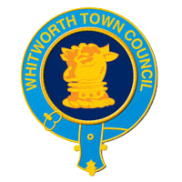
The Whitworth Crest
In October 1874, the Whitworth Local Board (precursor to the Urban District Council) was set up with 12 elected members. One of the members was Mr James Henry Scholfield, of North View, Whitworth. The Crest of his Coat of Arms depicted a bull, and it was this which by tacit agreement was used on the Board's and later the District Council's stationery. The encirclement was added to contain the Town's name. In 1937, to commemorate the Coronation of King George VI, Mr Frank Holt, a former Chairman of the Urban District Council, offered to donate a gold Chain of Office, together with a pendant Badge. The badge was to include the crest, and so to regularise its use the Council decided to write to Rev James Ralph Scholfield, the son of Mr J.H. Scholfield and vicar for a number of years at St Bartholomew's Church, to obtain his permission. Mr J. R. Scholfield wrote back to confirm that 'it certainly is the Scholfield crest', and that although 'I have no idea as to how the crest was given for use by the Council,' nevertheless, 'I think the gold chain a splendid idea, I shall be proud to think that you have given our crest a place upon it.' The Chain and Badge was presented to the Council in May 1937 and cost Mr. Holt £105. The Whitworth crest depicts a bull's head 'erased and gorged', meaning that the head was dragged from the body, gorged meaning "with collar".